- Maryland Route 528
-
Maryland Route 528
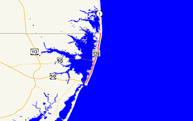
Maryland Route 528 highlighted in redRoute information Maintained by MDSHA Length: 9.04 mi[1] (14.55 km) Major junctions South end:  MD 378 in Ocean City
 US 50 in Ocean City
 MD 90 in Ocean City
North end:  DE 1 in Ocean City
Location Counties: Worcester Highway system Maryland highway system
Interstate • US • State • Minor • Former • Turnpikes←  MD 527
MD 529  →
→Maryland Route 528 (MD 528) is a state highway in the U.S. state of Maryland. Known for most of its length as Coastal Highway, the state highway runs 9.04 miles (14.55 km) from the southern terminus of its companion route, unsigned Maryland Route 378, in downtown Ocean City north to the Delaware state line at the northern edge of the resort town, where the state highway continues as Delaware Route 1 (DE 1). In downtown Ocean City, MD 378 and MD 528 form a one-way pair, with MD 378 following Baltimore Avenue northbound and MD 528 following Philadelphia Avenue northbound. The two state highways meet the eastern terminus of U.S. Route 50 (US 50) in the downtown area. North of downtown, MD 528 is Coastal Highway, a six-lane divided highway that forms the transportation backbone of the resort town, providing access to the eastern terminus of MD 90, the southern terminus of DE 1, and the eastern terminus of DE 54. As the main access highway to countless hotels, condos, restaurants, shops, and other businesses catering to tourists, MD 528 and MD 378 see heavy seasonal traffic. Due to their importance as the resort's sole conduits and providing access to evacuation routes, MD 528 and MD 378 are parts of the National Highway System between US 50 and the Delaware state line.[1][2]
Both Baltimore Avenue and Philadelphia Avenue date back to the founding of Ocean City in the late 19th century. MD 378 was assigned to Baltimore Avenue in 1927, while MD 528 was assigned to Philadelphia Avenue in 1933. MD 528 was extended north of 15th Street to the Delaware state line in 1939. Both highways were rebuilt and widened in the 1950s. MD 528 was expanded to a six-lane divided highway north of the one-way pair in the late 1980s.
Contents
Route description
MD 528 and MD 378 both have their southern termini at the intersection of Baltimore Avenue and South 1st Street at the southern end of Ocean City.[1][3] Baltimore Avenue continues south and then turns east toward a large municipal parking lot serving attractions on the Ocean City Boardwalk, including Trimper's Rides.[4] From the southern terminus, MD 528 heads west on South 1st Street and then north as Philadelphia Avenue, while MD 378 heads north as Baltimore Avenue.[1] The two state highways form a one-way pair, with MD 378 carrying three lanes of northbound traffic and MD 528 carrying three lanes of southbound traffic.[1] Both streets intersect South Division Street, which was formerly the site of the railroad terminus in Ocean City and currently the site of Sunset Park, and Worcester Street, which was formerly the site of the first automobile bridge to the resort in 1916.[5][4]
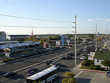 MD 528 looking north toward the intersection with 127th Street
MD 528 and MD 378 head north through the downtown area of Ocean City, where they meet the eastern terminus of US 50 at North Division Street.[4] North Division Street between MD 528 and MD 378 is one-way eastbound, so traffic coming from the south uses North 1st Street, which is one-way westbound and designated MD 378A, to access US 50 west.[1][4] MD 528 and MD 378 continue north to 9th Street, which is one-way westbound and designated MD 378B.[1] MD 528 becomes two-way at 9th Street.[3] MD 378 continues north as a two-lane street northbound to 15th Street, where the state highway turns left to reach its northern terminus at MD 528.[1][4] Baltimore Avenue continues north of 15th Street as a two-way municipal street to its northern end at 33rd Street.[4]
MD 528 heads north from 9th Street as Philadelphia Avenue, a divided highway with two lanes northbound and three lanes southbound. The state highway gains a third lane northbound at MD 378 (15th Street). At 17th Street, MD 528 assumes its form for the remainder of its course to the Delaware state line: three lanes in each direction plus continuous right turn and bus lanes. After passing the Jolly Roger Amusement Park, MD 528 meets 33rd Street, which is one-way westbound coming from the northern end of Baltimore Avenue.[3] North of 33rd Street, MD 528 becomes Coastal Highway, the only through highway on the barrier island. The state highway passes the Ocean City Convention Center at 40th Street and intersects the eastern terminus of MD 90 (Ocean City Expressway) at 62nd Street.[1][3] MD 528 continues north until it reaches the Delaware state line at 146th Street.[1] Coastal Highway continues into Fenwick Island as DE 1, which meets the eastern terminus of DE 54 one block north of the state line.[3]
History
Baltimore Avenue and Philadelphia Avenue date back to the founding of Ocean City in 1875. Both avenues originally extended from South Division Street to North Division Street.[6] The streets were later extended north as far as 15th Street.[7] Baltimore Avenue served as the main thoroughfare of Ocean City until Philadelphia Avenue and Coastal Highway assumed predominance in the 1950s.[8] As a result, MD 378 was assigned to Baltimore Avenue, which was paved from US 213 (Worcester Street) to 15th Street by 1927.[5][9] MD 528 was assigned to Philadelphia Avenue when that street was rebuilt between US 213 and 15th Street in 1933.[10] MD 528 was extended north to the Delaware state line when Coastal Highway was completed in 1939.[11][12]
Traffic in Ocean City had increased so much there was a movement to make Baltimore and Philadelphia Avenues one-way in the downtown area, a change that was implemented by 1948.[13][14] Traffic volume in Ocean City increased even more following the completion of the Chesapeake Bay Bridge in 1952, leading to expansion of the city's north–south arterials. MD 378 was widened along its entire length in 1951 and 1952.[15] MD 528 was widened to four lanes along its entire length in 1953 and 1954.[16] Both state highways were extended to their present southern termini at that time.[15] The first portion of MD 528 to be expanded to a divided highway was around the intersection with MD 90; the highway between 60th and 63rd Streets was reconstructed by 1978.[17] Two sections of six-lane divided highway were completed around 1989: from 25th Street to 65th Street, and from 85th Street to 122nd Street.[18] By 1991, MD 528 was divided highway from 25th Street to the Delaware state line.[19] The segment of Philadelphia Avenue from 9th Street to 25th Street was changed from a five- to six-lane highway with a center turn lane to a divided highway in 2001.[20]
Junction list
The entire route is in Ocean City, Worcester County.
Mile
[1]Destinations Notes 0.00 Baltimore Avenue south – Ocean City Boardwalk Southern terminus of one-way pair formed by MD 528 (southbound) on Philadelphia Avenue and unsigned MD 378 (northbound) on Baltimore Avenue MD 378 north (Baltimore Avenue)0.18 Worcester Avenue Original alignment of former US 213 0.43 US 50 (North Division Street) – West Ocean City, Salisbury0.53 1st Street Portion of 1st Street east of MD 528 is unsigned MD 378A; one-way street westbound 1.08 9th Street MD 528 becomes two-way at this intersection; portion of 9th Street east of MD 528 is unsigned MD 378B; one-way street westbound 1.47 MD 378 (15th Street)Northern terminus of MD 378; MD 378 is one-way street westbound 2.65 33rd Street 33rd Street is one-way westbound on east side of intersection 4.33 MD 90 west (Ocean City Expressway) / 62nd Street east – Salisbury, Bay Bridge6.07 94th Street 9.04 146th Street Northern terminus of MD 528; Delaware state line  DE 1 north (Coastal Highway) to DE 54 west (Lighthouse Road) – Fenwick Island, DE, Rehoboth Beach, DE, Selbyville, DE
MD 378
Maryland Route 378
Location: Ocean City Length: 1.49 mi[1] (2.40 km) MD 378 is the unsigned designation for Baltimore Avenue and 15th Street, a 1.49-mile (2.40 km) highway that runs from the southern terminus of MD 528 at the southern end of Ocean City north to MD 528 north of the downtown area of Ocean City.[1][4] As MD 378 is effectively the northbound direction of MD 528 in downtown Ocean City, the state highway is covered in more detail in the main sections of this article. MD 378 has two auxiliary routes:
- MD 378A is the designation for 1st Street, a 0.07-mile (0.11 km) connector between MD 378 and MD 528 just north of US 50 in Ocean City.[1] The state highway is one-way westbound, helping provide access to US 50 from traffic at the southern end of the barrier island.[21]
- MD 378B is the designation for 9th Street, a 0.07-mile (0.11 km) connector between MD 378 and MD 528 on the northern edge of downtown Ocean City.[1] MD 378B, which is one-way westbound, serves as the main conduit for MD 378 traffic headed for the central and northern parts of Ocean City along MD 528, connecting with MD 528 at the point the highway becomes two-way.[22] For that reason, MD 378B is part of the National Highway System.[1]
References
- ^ a b c d e f g h i j k l m n o p "Highway Location Reference: Worcester County" (PDF). Maryland State Highway Administration. 2009. http://www.marylandroads.com/Location/2009_WORCESTER.pdf. Retrieved 2010-10-26.
- ^ Federal Highway Administration (August 2003) (PDF). National Highway System: Maryland (Map). http://www.fhwa.dot.gov/planning/nhs/maps/md/md_Maryland.pdf. Retrieved 2010-04-05.
- ^ a b c d e Google, Inc. Google Maps – Maryland Route 528 (Map). Cartography by Google, Inc. http://maps.google.com/maps?f=d&source=s_d&saddr=Coastal+Hwy%2FDE-1+N&daddr=S+Baltimore+Ave&geocode=FUq4SgIdTsuG-w%3BFZTQSAIdQjyG-w&hl=en&mra=ls&sll=38.389275,-75.071035&sspn=0.247033,0.617294&ie=UTF8&t=h&z=11. Retrieved 2010-04-05.
- ^ a b c d e f g Google, Inc. Google Maps – Maryland Route 378 (Map). Cartography by Google, Inc. http://maps.google.com/maps?f=d&source=s_d&saddr=S+Baltimore+Ave&daddr=N+Baltimore+Ave+to:15th+St&geocode=FZTQSAIdQjyG-w%3BFQcHSQIdDlmG-w%3BFaUaSQId8F6G-w&hl=en&mra=ls&sll=38.345645,-75.077648&sspn=0.007724,0.01929&ie=UTF8&t=h&z=14. Retrieved 2010-04-05.
- ^ a b Reno, Sheri (2007). "Railway Brings Travelers". Ocean City Live-Saving Station Museum. Ocean City Museum Society. http://www.ocmuseum.org/index.php/site/oc-history_article/railway_brings_travelers/. Retrieved 2010-04-05.
- ^ Katz, Gordon. "Saint Mary Star-of-the-Sea Catholic Church". Ocean City Live-Saving Station Museum. Ocean City Museum Society. http://www.ocmuseum.org/index.php/site/oc-history_article/saint_mary_star_of_the_sea/. Retrieved 2010-04-05.
- ^ Hurley, Suzanne B.. "Maryland’s Only Sea Side Resort". Ocean City Live-Saving Station Museum. Ocean City Museum Society. http://www.ocmuseum.org/index.php/site/oc-history_article/marylands_only_sea_side_resort/. Retrieved 2010-04-05.
- ^ Hurley, Suzanne B. (2007). "Stormy Weather". Ocean City Live-Saving Station Museum. Ocean City Museum Society. http://www.ocmuseum.org/index.php/site/oc-history_article/stormy_weather/. Retrieved 2010-04-05.
- ^ Maryland Geological Survey. Map of Maryland: Showing State Road System and State Aid Roads (Map) (1927 ed.).
- ^ Report of the State Roads Commission of Maryland. 1931-1934. Baltimore: Maryland State Roads Commission. 1934-12-28. p. 362. http://www.archive.org/details/reportofstateroa1931mary. Retrieved 2010-04-05.
- ^ Report of the State Roads Commission of Maryland. 1939-1940. Baltimore: Maryland State Roads Commission. 1941-03-15. p. 85. http://www.archive.org/details/reportofstateroa1939mary. Retrieved 2010-04-05.
- ^ Maryland State Roads Commission. General Highway Map: State of Maryland (Map) (1939 ed.).
- ^ "Ocean City Considers One-Way Streets". The Sunday Morning Star (Wilmington, DE: Star Publishing Company): p. 9. 1940-08-25.
- ^ "Ocean City Preparing". The Baltimore Sun (Baltimore: Tribune Company): p. 11. 1948-03-22.
- ^ a b Report of the State Roads Commission of Maryland. 1951-1952. Baltimore: Maryland State Roads Commission. 1952-12-15. pp. 114–115. http://www.archive.org/details/reportofstateroa1951mary. Retrieved 2010-04-05.
- ^ Report of the State Roads Commission of Maryland. 1953-1954. Baltimore: Maryland State Roads Commission. 1954-11-12. p. 133. http://www.archive.org/details/reportofstateroa1953mary. Retrieved 2010-04-05.
- ^ Maryland State Highway Administration. Maryland: Official Highway Map (Map) (1978 ed.).
- ^ Maryland State Highway Administration. Maryland: Official Highway Map (Map) (1989 ed.).
- ^ Maryland State Highway Administration. Maryland: Official Highway Map (Map) (1991 ed.).
- ^ "Highway Location Reference: Worcester County" (PDF). Maryland State Highway Administration. 2001. http://www.marylandroads.com/Location/2001_WORCESTER.pdf. Retrieved 2010-10-26.
- ^ Google, Inc. Google Maps – Maryland Route 378A (Map). Cartography by Google, Inc. http://maps.google.com/maps?f=d&source=s_d&saddr=N+1st+St&daddr=N+1st+St&geocode=FeDoSAId9EiG-w%3BFYTqSAIdEkSG-w&hl=en&mra=ls&sll=38.332626,-75.085062&sspn=0.003863,0.009645&ie=UTF8&t=h&z=19. Retrieved 2010-04-05.
- ^ Google, Inc. Google Maps – Maryland Route 378B (Map). Cartography by Google, Inc. http://maps.google.com/maps?f=d&source=s_d&saddr=9th+St&daddr=9th+St&geocode=FRQFSQId_leG-w%3BFZAGSQIdgFOG-w&hl=en&mra=ls&sll=38.339275,-75.082787&sspn=0.003863,0.009645&ie=UTF8&t=h&z=20. Retrieved 2010-04-05.
External links
Roads in Worcester County, Maryland State highways 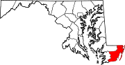
U.S. Highways Categories:- State highways in Maryland
- Roads in Worcester County, Maryland


Wikimedia Foundation. 2010.