- GPS navigation device
-
 Bicycle navigation with Gosmore, an open source routing software, on a personal navigation assistant with free map data from OpenStreetMap.
A GPS navigation device is any device that receives Global Positioning System (GPS) signals for the purpose of determining the device's current location on Earth. GPS devices provide latitude and longitude information, and some may also calculate altitude, although this is not considered sufficiently accurate or continuously available enough (due to the possibility of signal blockage and other factors) to rely on exclusively to pilot aircraft. GPS devices are used in military, aviation, marine and consumer product applications.
GPS devices may also have additional capabilities such as:
- containing maps, which may be displayed in human readable format via text or in a graphical format
- providing suggested directions to a human in charge of a vehicle or vessel via text or speech
- providing directions directly to an autonomous vehicle such as a robotic probe
- providing information on traffic conditions (either via historical or real time data) and suggesting alternative directions
- providing information on nearby amenities such as restaurants, fueling stations, etc.
In other words, all GPS devices can answer the question "Where am I?", and may also be able to answer:
- which roads or paths are available to me now?
- which roads or paths should I take in order to get to my desired destination?
- if some roads are usually busy at this time or are busy right now, what would be a better route to take?
- where can I get something to eat nearby or where can I get fuel for my vehicle?
Contents
Consumer applications
Consumer GPS navigation devices include:
- Dedicated GPS navigation devices
- GPS modules that need to be connected to a computer to be used
- GPS loggers that record trip information for download. Such GPS tracking is useful for trailblazing, mapping by hikers and cyclists, and the production of geocoded photographs.
- Converged devices, including GPS Phones and GPS cameras, in which GPS is a feature rather than the main purpose of the device. Those devices are the majority, and may use assisted GPS or standalone (not network dependent) or both. The vulnerability of consumer GPS to radio frequency interference from planned wireless data services is controversial.
See also: automotive navigation system and personal navigation assistant A variety of hand-held receivers
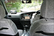 A taxi equipped with GPS navigation system
Dedicated devices have various degrees of mobility. Hand-held, outdoor, or sport receivers have replaceable batteries that can run them for several hours, making them suitable for hiking, bicycle touring and other activities far from an electric power source. Their screens are small, and some do not show color, in part to save power. Cases are rugged and some are water resistant.
Other receivers, often called mobile are intended primarily for use in a car, but have a small rechargeable internal battery that can power them for an hour or two away from the car. Special purpose devices for use in a car may be permanently installed and depend entirely on the automotive electrical system.
The pre-installed embedded software of early receivers did not display maps; 21st century ones commonly show interactive street maps (of certain regions) that may also show points of interest, route information and step-by-step routing directions, often in spoken form with a feature called "text to speech".
Manufacturers include:
- Navman products
- TomTom products
- Garmin products
- Mio products
- Navigon products
- Magellan Navigation consumer products
- TeleType products
Mobile phones with GPS capability
Due in part to regulations encouraging mobile phone tracking, including E911, the majority of GPS receivers are built into mobile telephones, with varying degrees of coverage and user accessibility. Commercial navigation software is available for most 21st century smartphones as well as some Java-enabled phones that allows them to use an internal or external GPS receiver (in the latter case, connecting via serial or Bluetooth). Some phones with GPS capability work by assisted GPS (A-GPS) only,[dubious ] and do not function when out of range of their carrier's cell towers. Others can navigate worldwide with satellite GPS signals as a dedicated portable GPS receiver does, upgrading their operation to A-GPS mode when in range. Still others have a hybrid positioning system that can use other signals when GPS signals are inadequate.
More bespoke solutions also exist for smartphones with inbuilt GPS capabilities. Some such phones can use tethering to double as a wireless modem for a laptop, while allowing GPS-navigation/localisation as well.[1] One such example is marketed by Verizon Wireless in the United States, and is called VZ Navigator. The system uses gpsOne technology to determine the location, and then uses the mobile phone's data connection to download maps and calculate navigational routes. Other products including iPhone are used to provide similar services. Nokia gives Ovi Maps free on its smartphones and maps can be preloaded. According to market research from the independent analyst firm Berg Insight, the sales of GPS-enabled GSM/WCDMA handsets was 150 million units in 2009,[2] while only 40 million separate GPS receivers were sold.[3]
GPS navigation applications for mobile phones include Waze and Google Maps Navigation. Google Maps Navigation included with Android means most smartphone users only need their phone to have a personal navigation assistant.
Laptop PC GPS
Various software companies have made available GPS navigation software programs for in-vehicle use on laptop computers.[4] Benefits of GPS on a laptop include larger map overview, ability to use the keyboard to control GPS functions, and some GPS software for laptops offers advanced trip-planning features not available on other platforms.
GPS modules
 A modern SiRFstarIII chip based 20-channel GPS receiver with WAAS/EGNOS support.
Other GPS devices need to be connected to a computer in order to work. This computer can be a home computer, laptop or even a PDAs, or smartphones. Depending on the type of computer and available connectors, connections can be made through a serial or USB cable, as well as Bluetooth, CompactFlash, SD, PCMCIA and the newer ExpressCard.[5] Some PCMCIA/ExpressCard GPS units also include a wireless modem.[6] Devices usually do not come with pre-installed GPS navigation software, thus, once purchased, the user must install or write their own software. As the user can choose which software to use, it can be better matched to their personal taste. It is very common for a PC-based GPS receiver to come bundled with a navigation software suite. Also, GPS modules are significantly cheaper than complete stand-alone systems (around €50 to €100). The software may include maps only for a particular region, or the entire world, if softwares such as Google Maps, Networks in Motion's AtlasBook mobile navigation platform, etc., are used.
Some hobbyists have also made some GPS devices and open-sourced the plans. Examples include the Elektor GPS units. These are based around a SiRFstarIII chip and are comparable to their commercial counterparts.
Commercial aviation
Commercial aviation applications include GPS devices that calculate location and feed that information to large multi-input navigational computers for autopilot, course information and correction displays to the pilots, and course tracking and recording devices.
Military
Military applications include devices similar to consumer sport products for foot soldiers (commanders and regular soldiers), small vehicles and ships, and devices similar to commercial aviation applications for aircraft and missiles. Examples are the United States military's Commander's Digital Assistant and the Soldier Digital Assistant.[7][8][9][10]
See also
References
- ^ Example of hook-up of GPS-phone as wireless modem and GPS receiver[dead link]
- ^ GPS and Mobile Handsets - 4th edition
- ^ Kevin J. O'Brien, New York Times, 2010 Nov 15 Smartphone Sales Taking Toll on G.P.S. Devices
- ^ List of laptop GPS navigation software programs and reviews
- ^ PCMCIA GPS adaptors
- ^ GPS ExpressCard with wireless modem[dead link]
- ^ Commanders Digital Assistant explanation and photo
- ^ Latest version Commanders Digital Assistant
- ^ Soldier Digital Assistant explanation and photo
- ^ Commanders and Soldiers' GPS receivers
Categories:- GPS
- GPS navigation devices


Wikimedia Foundation. 2010.