- Marcinkonys
-
Marcinkonys — Village — Wooden church of Marcinkonys (built 1880)

Coat of armsLocation of Marcinkonys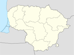
 Marcinkonys
Coordinates: 54°03′40″N 24°24′0″E / 54.06111°N 24.4°ECoordinates: 54°03′40″N 24°24′0″E / 54.06111°N 24.4°E Country  Lithuania
Ethnographic region Dzūkija County  Alytus County
Municipality Varėna district municipality Eldership Marcinkonys eldership Capital of Marcinkonys eldership Population (2001) – Total 765 Time zone EET (UTC+2) – Summer (DST) EEST (UTC+3) Marcinkonys is a village in Varėna district, Lithuania, located south-east of Merkinė. It is the administrative center of the Dzūkija National Park and Čepkeliai Marsh. According to the 2001 census, it had 765 residents.[1] The settlement is known since 1637, when it was a camp of foresters. It began growing after completion of the train station for the Warsaw – Saint Petersburg Railway in 1864. During the Holocaust, the village had the Marcinkonys Ghetto for the Lithuanian Jews. Some Jews escaped during the liquidation of the ghetto and managed to survive the war.[2]
References
- ^ (Lithuanian) Alytaus apskrities kaimo gyvenamosios vietovės ir jų gyventojai. Vilnius: Department of Statistics to the Government of the Republic of Lithuania. 2002. p. 55. ISBN 9986-589-83-5. http://www.stat.gov.lt/uploads/docs/Alytaus_apskritis.pdf.
- ^ Browning, Christopher R. (2000). Nazi policy, Jewish workers, German killers. Cambridge University Press. pp. 157–160, 166. ISBN 9780521774901. http://books.google.com/books?id=Ewncj-TwLycC&pg=PA159.
Alytus County Municipalities 
Cities Towns Butrimonys • Kapčiamiestis • Krokialaukis • Krosna • Leipalingis • Merkinė • Nemunaitis • Rudamina • Seirijai • Šeštokai • Šventežeris • ValkininkaiVillages Villages (click "Show" to display)Akmuo • Aladiškės • Andriūnai • Aukštakalnis • Ašašninkai • Babriškės • Bagočiai • Balbutai • Barteliai • Barčiai • Bingeliai • Burokaraistis • Butvydonys • Čebatoriai • Česukai • Čižiūnai • Dainava • Dargužiai • Darželiai • Daržininkai • Daržinėlės • Degsnės • Druckūnai • Dubininkas • Dubičiai • Ežeriekai • Geidukonys • Geniai • Genionys • Giraitė • Glūkas • Grybaulia • Gudakiemis • Gudeliai • Gudžiai • Ilgininkai • Jakėnai • Jasauskai • Jonionių gyvenvietės • Jonionys • Jurgiškės • Kabeliai • Kalviai • Kaniava • Kaniavėlė • Kaniūkai (Jakėnai) • Kaniūkai (Kaniava) • Kapiniškiai • Kareivonys • Karužai • Kasčiūnai • Kašėtos • Kašėtų gyvenvietės • Katra • Kibyšiai • Kijučiai • Kirklionys • Kriviliai • Krokšlys • Krūminiai • Kudrėnai • Kukliai • Kurmiškė • Kuršiai • Liškiava • Luksnėnai • Lynežeris • Maksimai • Maksimonys • Mantvilai • Mančiagirė • Marcinkonys • Mardasavas (Marcinkonys) • Mardasavas (Merkinė) • Margionys • Masališkės • Matuizos • Mergežeris • Meškučiai • Mielupiai • Miklusėnai • Musteika • Nedzingė • Noruliai • Noškūnai • Paąžuolė • Pabezninkai • Pagilšys • Paklėštarė • Palkabalis • Pamerkiai • Pamusiai • Panočiai • Papiškės • Paručiai • Pavarėnis • Paversekis • Perloja • Pilvingiai • Pirčiupiai • Punia • Puodžiai • Puvočiai • Pūčkornės • Radyščius • Radžiūnai • Roduka • Rudnia • Rūsingė • Samūniškės • Sarapiniškės • Šarkiškės • Senoji Varėna • Senovė • Šklėriai • Subartonys • Tolkūnai • Trakiškiai • Trasninkas • Ūdrija • Urkionys • Ūta • Užuperkasis • Vazgirdonys • Venciūnai • Vilkiautinis • Voriškės • Vydeniai • Zakavoliai • Žeimiai • Zervynos • Žilinai • Žiūrai
Categories:- Villages in Alytus County
- Lithuania geography stubs


Wikimedia Foundation. 2010.