- Brazilian Federal District
-
Brazilian Federal District — Federal district — The city seen from the subway station of Águas Claras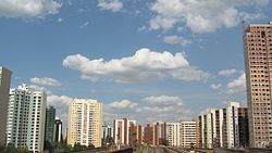

Flag
Coat of armsLocation of Brazilian Federal District in Brazil
Coordinates: 15°47′S 47°56′W / 15.783°S 47.933°WCoordinates: 15°47′S 47°56′W / 15.783°S 47.933°W Country  Brazil
Capital Brasília Government - Governor Agnelo Queiroz (PT) Area - Total 5,802 km2 (2,240.2 sq mi) Area rank 27th Population (2006 census) - Total 2,337,078 - Estimate (2008) 2,557,158 - Rank 20th - Density 402.8/km2 (1,043.3/sq mi) - Density rank 1st Demonym Brasiliense GDP - Year 2006 estimate - Total R$ 89,630,000,000 (8th) - Per capita R$ 37,600 (1st) HDI - Year 2005 - Category 0.874 – high (1st) Time zone BRT (UTC-3) - Summer (DST) BRST (UTC-2) Postal Code 70000-000 to 73690-000 ISO 3166 code BR-DF The Federal District (Portuguese: Distrito Federal, Portuguese pronunciation: [dʒisˈtɾitu fedeˈɾaw]) is set apart for Brasília, the capital of Brazil. Located in a region called Planalto Central, or Central Plateau, the Federal District is divided in 29 administrative regions. Brasilia - place where the three branches of the Federal Government are located - is the main attraction of this dry area and climate with only two seasons. During the dry season (winter), the humidity can reach critical levels, mainly in the peak hours of the hottest days. The artificial lake of Paranoá, with almost 40 km2 (15 sq mi) and 500 million cubic metres (410,000 acre·ft) of water, was built exactly to minimize the severe dry climatic conditions of winter in the cerrado—savannah-like vegetation. Besides businessmen and politicians, the region also attracts mystics and there are several syncretic or spiritualistic temples mainly near nature here.
Contents
History
The civil government was transferred from Rio de Janeiro's Catete Palace to Brasília on April 21, 1960, which was then split off from Goiás (major part) and Minas Gerais. After the transfer, the municipality of Rio de Janeiro became the Estado da Guanabara (State of Guanabara), which existed from 1960 until 1975 when the State of Guanabara and the State of Rio de Janeiro merged and assumed the name of Rio de Janeiro State, having as capital the city of Rio de Janeiro.
Originally, the majority of the population consisted of "Candango" workers from other states who built the capital and federal government employees who were transferred to the new capital. The capital is a thoroughly planned city with designated areas for residence, businesses, schools, churches, etc. No streets have names, but are identified instead by letters and numbers arranged in a geographical system according to blocs (Q-Quadras) and sectors (S-Setor e.g.: SB - Setor Bancario or "Bank Section"). Originally built for up to one million inhabitants, the city now has more than twice that number. Due to its complex organization, the growth of the city itself has been slow. This has forced many to settle in neighboring cities around Brasília, which now house a significant percentage of the whole population.
Demographics
According to the IBGE of 2007, there were 2,393,000 people residing in the Brazilian Federal District. The population density was 410.9 inhabitants per square kilometre (1,064 /sq mi).
- Urbanization: 94% (2006)
- Population growth: 2.8% (1991–2000)
- Houses: 697,000 (2006).[1]
The last PNAD (National Research for Sample of Domiciles) census revealed the following numbers: 1,253,000 Brown (Multiracial) people (49.60%), 1,045,000 White people (41.37%), 206,000 Black people (8.14%), 11,000 Asian people (0.44%), 8,000 Amerindian people (0.33%).[2]
Geography
The Brazilian Federal District is more than double the size of: Tokyo (Japan) and island of Maui (Hawaii, USA). It is slightly larger than the French Polynesia, the US State of Rhode Island, and Cape Verde. It is slightly smaller than: Bali (Indonesia) and Trinidad and Tobago.
Tourism and recreation
 The "Parque da Cidade" ("City Park")
 Catedral Metropolitana Nossa Senhora Aparecida.
The "Parque da Cidade" Located in Brasília, the "Parque da Cidade" ("City Park"), which is named after the wife of Brazilian president Juscelino Kubitschek, extends over four million square meters. It includes landscape works of Burle Marx, and wall tiles that decorate restrooms in the Park designed by Athos Bulcão. Equipped with sports courts, a horse track, a racing kart track, skate tracks, playgrounds for children, bicycle tracks and trails for walks and jogging, the City Park attracts hundreds of people everyday, specially on weekends. The Park's main entrance is located in the Monumental Axle South, but there are secondary exits that lead to other areas in the city's South Wing.
The Metropolitan Cathedral of Brasilia Designed by Oscar Niemeyer, it was inaugurated in 1970. Its shape is circular horizontally and structured around 16 curved pillars, forming a crown filled with futuristic and/or spatial stained-glass works in a triangular shape. The pillars evoke reversed praying hands that deconstruct the gothic traditional church window pattern, but conserves the triangular vaginal shape of the stained-glasses. The curves present in many of Niemeyer's works pay homage to the beautifully-built bodies of Brazilian women.
The stained-glasses were designed by Marianne Peretti. Their disposition ensures natural lighting into the aisle, which was built below street level. Around the church, in the outside area, visitors can see Alfredo Ceschiatti's sculptures – the four evangelists – and inside, suspended angels. There are also paintings by Di Cavalcanti, representing the stages of the Passion of Christ, and paintings by Athos Bulcão. The Cathedral is located in the Eixo Monumental mall, at the entry to the Esplanada dos Ministerios, or Ministries Sector.
The "Three Powers Square"
Praça dos Três Poderes concentrates some of the most important and significant buildings in the work and career of Oscar Niemeyer – the Planalto Palace, headquarters of Brazilian Presidency; the National Congress, hosting the Chamber of Deputies and the Federal Senate; and the Higher Courts of Justice. The Square also hosts: the "Panteão da Pátria" (the Motherland Pantheon), the Lúcio Costa Space and three important sculptures – "Pombal", by Niemeyer; "Justice", by Alfredo Ceschiatti; and "Os Candangos", by Bruno Giorgi. In the central plaza, a giant Brazilian national flag 286 square meters (3,080 sq ft) is supported by a triangular black 100-metre (330 ft) and high pole. It is located at the end of the Esplanada dos Ministerios.
Infrastructure
 Esplanade of the Ministries and Central Bus Station (Rodoviária)
- Vehicles: 910,502 (March/2007)
- Mobile phones: 2.7 million (April/2007)
- Telephones: 884 thousand (April/2007)
- Cities: 1 (2007).[3]
Economy
The service sector is the largest component of GDP at 92.5%, followed by the industrial sector at 7.1%. Agriculture represents 0.4% of GDP (2004). Brazilian Federal District exports: soybean 77.1% and gold 16.4% (2002). The Brazilian Federal District's share of the Brazilian economy is 3.7% as of 2005.[citation needed]
Education
 National Museum of Brasília.
Educational institutions
- Universidade de Brasília (UnB) (University of Brasília);
- Universidade Católica de Brasília (UCB) (Catholic University of Brasília);
- Centro Universitário de Brasília (UniCEUB);
- Centro Universitário do Distrito Federal (UniDF);
- Centro Universitário Euroamericano (UNIEURO);
- Instituto de Educação Superior de Brasília (IESB);
- União Pioneira da Integração Social (UPIS);
- Universidade Paulista (UniP) (Paulista University)
Infrastructure
International Airport
Brasília International Airport is the third largest in Brazil in terms of passenger movement. Because of its strategic location it is considered a civil aviation hub for the rest of the country. This makes for a large number of takeoffs and landings and it is not unusual for flights to have to wait in the holding pattern to land. Following the airport's master plan, Infraero built a second runway in 2005. In 2003, the fourth phase of the passenger terminal expansion was completed. It raised its capacity to 7.4 million passengers a year. The third floor of the main building, with 12 thousand square meters, has a panoramic deck, a food court, shops, four movie theaters with total capacity of 500 people, and space for exhibitions. There are a total of 136 shop spots at the Brasília Airport.
Subway
 The subway
Brasília's Subway is the rail system of Distrito Federal. It is operated by Metrô-DF (Companhia do Metropolitano do Distrito Federal). and opened in 2001. The system has ten stations on two lines in operation from 6:00 AM to 11:30 PM, Monday through Friday. It covers most of the metropolitan area. Its main problem is the sheer distance between stations, making it a small component in the Federal District transit system, where a dysfunctional bus network is still predominant. The city of Águas Claras is well-served by the subway, making it one of the fastest-growing areas in Brasilia.
Sports
Free Flying
Brasília is known as a departing point for the practice of free flying sports, a sport that may be practiced with Hang Gliding or Paragliding wings. Practitioners of such sports reveal that, because of the city's dry weather, the city offers strong thermal winds and great "cloud-streets" – which is also the name for a manoeuvre quite appreciated by practitioners. The national capital hosted the 14th Hang Gliding World Championship – one of the categories of free flying – in 2003. In August 2005, it hosted the 2nd stage of the Brazilian Hang Gliding Championship.
Brasília is one of the 12 cities to host games of the 2014 FIFA World Cup, to take place in the country.
Flag
 The flag of the Brazilian Federal District
The white background of the flag stands for peace, and gives the idea of infinity, or the vast Brazilian territory. The green and yellow colours in the middle refer to the most commonly used of the four colours of the national flag to represent Brazil. The four yellow arrows symbolize the native nations of Brazil, whereas their pointing into the four cardinal directions of the compass stands for the centralized emanating political power of Brasilia, as the capital of the country. The yellow arrows also form a cross, which symbolizes both the Southern Cross, a constellation seen only in the Southern Hemisphere and the Roman Catholic or Christian symbol of redemption brought by Pedro Álvares Cabral and under whose shadow the first Mass in Brazil was celebrated in 1500 in Bahia. With their feathers, the arrows form a lozange in the middle, a reference to yellow lozange of the national flag, that stands for Brazil's mineral riches.
The flag was created by the poet and herald Guilherme de Almeida, and was adopted by decree n.o 1090 on August 25, 1969.
Voting rights
Residents of the Federal District elect eight representatives to the Chamber of Deputies and three senators.
Judicial system
 The Supreme Tribunal
The highest judicial body is the Supreme Tribunal of Justice.
See also

Brazil portal References
- ^ Source: PNAD.
- ^ (in Portuguese) (PDF). Brazilian Federal District, Brazil: IBGE. 2008. ISBN 85-240-3919-1. http://www.sidra.ibge.gov.br/bda/tabela/listabl.asp?z=pnad&o=3&i=P&c=262. Retrieved 2010-01-18.
- ^ Source: IBGE.
External links
- (Portuguese) Official Website
- (Portuguese) Brasilia Guide with 360º photos
- (English) Brazilian Tourism Portal
- (English) Map of the Brazilian Federal District
BrazilHistory First inhabitants · Colonization · Empire · Old Republic · Vargas Era · Second Republic · Military rule · ContemporaryGeography Regions · States · Mesoregions · Microregions · Municipalities · Islands · Coastline · Climate · Environment · Extreme points · Protected areas · CapitalsGovernment Constitution · Federal government · President · National Congress · Foreign relations · Law · Law enforcement · MilitaryPolitics Economy Society Demographics · People · Languages · Religion · Immigration · Education · Health · Crime · Social issues · Largest cities · ApartheidCulture  Category ·
  Portal ·
  WikiProject
Demographics of Brazil Economic and social Apartheid · Attractions · Law · Crime · Education · GDP · Health · Human Development · Human Rights (LGBT Rights) · Immigration · Languages · People · Politics · Poverty · Races · Religions · Traditions · Wealth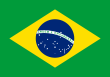
Ethnic groups BrazilAfricaAmericasNorth AmericaCaribbeanHaitianSouth AmericaBy EthnicityBy Country
or RegionEasternSouthernEast IndianWesternEuropeBy EthnicityBy Country
or RegionNorthernWesternCentralSouthernBalkanEasternRegions and States of Brazil North Northeast Center-West - Goiás
- Mato Grosso
- Mato Grosso do Sul
- Federal District
Southeast South - Fernando de Noronha
- Rocas Atoll
- Saint Peter and Saint Paul
- Trindade and Martim Vaz
Categories:- States of Brazil
- Capital districts and territories
- Brasília
- States and territories established in 1960


Wikimedia Foundation. 2010.